Navigation
New forum topics
Syndicate
Map integration in BT747
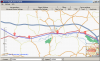 BT747 (development version) now integrates a map interface. It can show tracks and waypoints.
This will currently help you to finetune the filtering or simply to get a rough idea of the tracks that you logged.
Defining Waypoint Types
I am in the process of adding geotagging capability to BT747. This means that in the near future, BT747 will be able to place JPG files on the map and later on put the geoinformation in the JPG files.
I will introduce the notion of 'tag type' or rather convert the notion of 'rcr' or 'Record Reason' into tag type (or tag for simplicity).
Installing BT_J2ME (the mobile BT747)
 Any phone not being too strict on 'security' with a CLDC 1.1 / MIDP 2.0 profile and JSR82 support (bluetooth library) should be able to run the J2ME version of BT747 (if the specification says MIDP2.0, it is probably OK. For a list of known phones, see further below (leave a message in the forum if your phone is not on the list). Here is a first throw at explaining how to get BT747 on your phone!

Translators Wanted
Sun, 11/09/2008 - 12:47 — mdeweerdThe Desktop version of BT747 can be easily translated in other languages. Even though I know four languages, this small list does not cover the entire world. In the mean time, thanks to volunteers, the development version has more or less complete implementations of the application in: - English, German, Dutch, French, Spanish, Chinese, Italian and Russian. If you are interested in helping out to translate BT747 to your language, let me know. No coding is needed - simple editing of a text file only (Bundle.properties in particular).
Sharing Your Tracks Without Uploading Your Data
Sharing your data without putting it on the web is very easy. The map just below is a small single file that you can send by e-mail to any of your friends - you can do it with any of your GPS data!